Hike #1 :: Ballard Locks / Discovery Park :: 6.0 miles :: Sunday

If this is your first time here, we recommend you review the brief WELCOME! section above, but you may simply continue reading about hike #1 as well...

Reflective reading:
"Even if you help only one person, that is enough.  You can do what I cannot. I can do what you cannot.  Together we can do something beautiful for God." -- "God has created us so we do small things with great love." -- St. Mother Teresa

"When we look at a pruned vineyard, we can hardly believe it will bear fruit.  But when harvest comes, we realize that the pruning allows the vines to concentrate their energy and produce more grapes.  Grateful people learn to celebrate even amid life's hard and harrowing memories because they know that pruning is no mere punishment, but preparation." -- Henri Nouwen

The number ONE (1) represents the Judaic concept of monotheism, later adopted by Christianity and Islam. The world's three Abrahamic religions are unified by this belief in one supreme, omniscient & omnipotent deity, whether called Jehovah, God or Allah.


Trail overview: Urban and forested hike on paved and dirt trails with moderate grades (elevation gain < 300') from Ballard Locks to Discovery Park.

Trail highlights: The local chapter of American Pilgrims on the Camino does a reflective walk along this path the second Sunday of every month. The Ballard Locks, an engineering marvel from the early 20th century, connected Seattle's freshwater Lake Union and Lake Washington to saltwater Puget Sound, expanding commerce and lowering Lake Washington by nine feet. A fish ladder (WC) on the south side of the locks (with viewing windows) allow salmon to climb 20 feet above sea level and access the streams and creeks of the Lake Washington watershed. Discovery Park offers well-signed forest hikes and beautiful views of Puget Sound.

Trailhead location: Parking is available on both the north and south sides of Ballard Locks. North trailhead (recommended) located at 3015 NW 54th St., Seattle WA...$2.50/hour. South trailhead located at Commodore Park (3330 W Commodore Way, Seattle, WA) which offers limited free parking.

Trail description: Begin at the entrance to Hiram Chittenden Locks (aka "Ballard Locks") and walk down the entry path, past the visitor center (WC) and enter the Carl English Botanical Garden by taking a right as you near the lock building, loop around uphill through the gardens and enjoy the viewpoint overlooking the entire lock complex. Cross the large lock and small lock using whichever gates are closed at the moment and continue south until you reach the fish ladder; enter the underground viewing area if desired. Take the path westbound along the south bank of the lock waterway and make your way uphill to the intersection of Commodore Way & 33rd Avenue.  

Follow the signs to Discovery Park uphill along 33rd Ave and cross the railroad tracks using the pedestrian bridge. Continue south along 32nd Avenue and then Government Way, passing Kiwanis Ravine until you reach the entrance to Discovery Park. Continue along Discovery Park Blvd., then turn left at the parking lot entrance. When you see the information kiosk on your right, follow the 300' dirt path to reach the Loop Trail. We will walk this trail clockwise, so turn left at the junction, heading west. The Loop Trail is well-signed, so at each intersection, look for a trail marker if you are uncertain of the way forward.  

When you reach the south parking lot (WC), continue across the entry road and along the Loop Trail until you reach the restrooms (WC) and water fountain. Shortly afterwards, the trail will open up to a large meadow, followed shortly by a series of viewpoints with gorgeous panoramas of Puget Sound...you can see Elliot Bay, Blake Island and Bainbridge Island.


Continue along the Loop Trail and when you reach the forested trail fork, take the path to the right (along the fence) instead of heading downhill. You will walk briefly along Discovery Park Blvd, cross a number of roads, then pass by Fort Lawton cemetery. Walk underneath Discovery Park Blvd., and proceed south on the trail until you reach our original trail junction. Continue back to the parking lot and then to the visitor center (WC). Exit the park and rejoin Government Way, retracing your steps down along 32nd Ave, the railroad overpass and 33rd Avenue. Enjoy another view of the Ballard Locks, then cross back over both locks (again, use whichever gate is closed at the time) until you reach the trailhead at the entrance parking lot.

Public transit options: Bus #44 stops at the entrance to Ballard Locks (north side of locks)

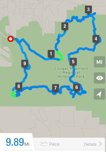
Hike #2 :: Cougar Mountain Loop :: 9.9 miles :: Monday


Reflective reading: To live a spiritual life we must find the courage to enter the desert of our loneliness and to change it by gentle and persistent efforts into a garden of solitude." -- Thomas Merton

"When real transformation does occur in someone's life, it usually happens through evolution, not revolution" --"Not knowing everything cannot be an excuse for not doing anything" -- "Not what we have, but what we enjoy, constitutes our abundance"  -- "How many people have put off the necessary, unglamorous work of building habits because they spend their lives waiting for an epiphany that never comes?" -- Eric Greitens


The number TWO (2) in Taoism represents the duality found in life (light/dark, fire/water, good/evil) and considers these complementary forces rather than oppositional, resulting in a synergy where the sum of the parts is greater than the whole.

Trail overview: This 10-mile trail winds along gravel and dirt paths through the heavily wooded and serene Cougar Mountain Regional Wildland Park (CMRWP), passing three peaks, two waterfalls and one scenic overlook. Absolute elevation gain is less than a thousand feet (640' to 1430') but cumulative elevation gain/loss is quite a bit more. If you use hiking poles, be sure to bring them along. We recommend that you download or screenshot the trail description and trail map since part of the trail will likely be without cell coverage.

Trail highlights:  CMRWP was former logging and coal mining territory, but nature has now had a half century to reclaim and beautify the landscape. Although the hike passes both Anti-Aircraft Peak (named for the AA battery installed there during WWII) and Long View Peak, the views are somewhat obscured due to heavy foliage. The park is very popular on weekends, which is why this hike is scheduled for a weekday. A short optional hike goes to North Fork Falls.

Trailhead location: CMRWP's main trailhead (Red Town) is located on Newcastle Golf Club Road (aka Lakemont Blvd), a quarter mile east of the club's entrance. An alternate parking lot is located just west of the club's entrance at Cinder Mine Trailhead.

Map: Overview map hike #2 // Cougar Mountain trails map

Overview map hike #2

Trail description: From the trailhead, head up Red Town Trail (W2), then left onto Cave Hole Trail (C3), then cross Clay Pit Road and join Coyote Creek Trail (N4), then a right onto Klondike Swamp Trail (N5) before taking a quick left onto Lost Beagle Trail (N6). At the summit, take the short spur trail (on left, thru the gap in the wire fence) to Anti-Aircraft Peak where you will find a broadcast tower. Head downhill on the access road to find restrooms and picnic tables. At the far end of the parking lot is a short spur trail to "Billion Dollar View"; that may be a bit of an overstatement, but there is a partially obscured view of Lake Sammamish worth at least $10K.


After a well deserved break, find the Harvey Manning Trail sign and head downhill to join Tibbetts Marsh Trail (N9) which you will now follow for awhile. Before heading uphill, turn right on Cougar Pass Trail (N8), then left on Klondike Swamp Trail (N5). You will then cross Clay Pit Road and join Fred's Railroad Trail (C7). Once you cross the East Fork of Coal Creek, join Shy Bear Trail (C7). When you reach Shy Bear Pass, you will have the option of taking a spur trail to Wilderness Peak, but the views are obscured, so we recommend you continue along on Long View Peak Trail (S4). A short spur trail leads to Long View Peak, but again, the views are obscured.  


Continue on twisty Deceiver Trail (S3) and take the short spur down to Doughty Falls, a seasonal waterfall. When you get to Shy Bear Trail (S2), turn left and head west, then take the loop around to Far Country Lookout with a bench and a partially obscured view of West Seattle and the Olympic mountains beyond.

Head downhill and turn right on Indian Trail (W7), take the short spur trail to Far Country Falls (another seasonal waterfall), then continue on W7 until you reach the junction where you will turn right on Red Town Trail (W2) and return to the trailhead parking lot.

A nice optional hike (0.4 miles round trip) once you return to the trailhead is to carefully cross Newcastle Golf Club Road and continue downhill for 5 minutes on Coal Creek Trail until you reach North Fork Falls which is the largest and most consistent waterfall in the park. On the way back, you can take the optional interpretative loop trail before returning to the Red Town trailhead.
Public transit options: None


Hike #3 :: Green River / Tukwila :: 10.5 miles :: Tuesday

Reflective reading:  
“But the fruit of the Spirit is love, joy, peace, patience, kindness, goodness, faithfulness, gentleness and self-control. Against such things there is no law.” (Galatians 5:22-23) -- “And we know that all things work together for good to them that love God, to them who are the called according to his purpose." (Romans 8:28)

"Grant us the strength and the courage to change the things which can be changed, the patience and serenity to accept the things which cannot, and the wisdom to distinguish between the two." -- Reinhold Niebuhr

The number THREE (3) is significant in Christianity as it references the concept of Trinity...God the Father, God the Son (Jesus) and God the Spirit...three as one.

Trail overview: Two-part (south & north sections), mostly level, paved trail along Green River and Black River through residential, commercial and industrial areas.

Trail highlights:  
South trail (4.7 miles) -- Fort Dent Park // Sounders training facility (WC + W) // Black River Riparian Forest // Waterworks Garden // Confluence of Green and Black Rivers

North trail 5.8 miles) -- Tukwila Community Center (WC + W) // Duwamish Garden Project // Cecil Moses Memorial Park (WC + W) // Duwamish Gardens // Duwamish Hill viewpoint // Green River & SEATAC departure viewpoint

Trailhead location:  
South trailhead --  Subway restaurant at 7100 Fun Center Way, Tukwila, WA
North trailhead -- Tukwila Community Center (TCC = 12424 42nd Ave S, Tukwila)

MapSouth trail map overview


North trail map overview


Trail description:  
South trail -- Entry to Green River Trail is behind the Subway restaurant (WC + W) near the large electrical tower.  Walk over pedestrian bridge (wide) #1, stay right to walk along river and behind the business park, cross river again using  pedestrian walkway (narrow) #2, loop around and under the bridge to stay on River Trail. Pass by soccer fields and Seattle Sounders FC training facility. Just before you cross the third pedestrian bridge, take the right fork onto the Black River spur trail. 


You can read the placard describing the fate of the Black River when the ship canal and locks were opened. We will learn more about this (both good and bad) on tomorrow’s hike (Cedar River hike #4). Walk under the railroad bridge, cross Monster Road, keep right on the other side and follow the trail into the Black River riparian forest. The trail winds along the north side of the forest and eventually exits into a shady business park. You will see the headquarters for the local Habitat for Humanity affiliate on the left. Continue down to SW 7th Street and take a right. At the stoplight continue straight ahead across Oakesdale Ave. Don’t be put off by the warning signs, for just past the bridge you will see a downhill “on-ramp” footpath leading to the main trail.  


Shortly thereafter take the left uphill “off-ramp” footpath followed by another left at the next fork onto the dirt path....just remember to keep left!


You now enter Waterworks Gardens and will see a series of terraced storm water ponds as you continue on a slightly uphill path. At the very top is a viewpoint that looks southwest towards Renton and Tukwila.


At the end of the footpath, turn right on Monster Road and walk downhill to Oakesdale then turn left. Just past KP Corp you will see the Black River spur trail again on the left. Retrace your steps and pass underneath the railroad bridge.


Once you reach the Green River trail junction, take a quick right and walk onto the bridge. To the right you will see where the Green and Black Rivers join. It is not much to look at now, but historically this was a significant and strategic location and the reason that Fort Dent was established here during the Civil War years.
Duwamish River convergence
Retrace your steps and join the maintenance road at Sounders training facility and walk around the parking lot and by the Watershed Cafe (WC).  Continue along the sidewalk, through the parking lot and cross 2nd (narrow) bridge again.  This time, stay straight, walk along roadway past Tahoma Clinic to rejoin the path.  Stay straight on Interurban Trail, re-crossing first (wide) pedestrian bridge and return to Subway parking lot.

North trail -- Exit TCC parking lot and turn right onto 42nd Ave S, past Harry’s Market, cross over river using the wooden pedestrian bridge on left, continue straight on 119th St until you can turn right onto Green River trail, continue under Marginal Way bridge and the hwy 99 bridge then loop around and over the river to north bank and continue, past six carved planks of the Duwamish Tribe, over another pedestrian bridge to Cecil Moses Memorial Park (WC & W).


Now, retrace steps until just before the Marginal Way and light rail bridges; turn right up a short dirt path to street level and cross river on bridge to explore Duwamish Gardens Park.  After exploring this nice little river park, carefully cross Marginal Way and continue down S 115th St then turn left into the Duwamish Hill Preserve. Follow the footpath and take the right fork (uphill) to view both the lower and upper viewpoints. When descending, walk into the residential neighborhood on S 133th St until you get to the bottom of the hill and turn left on 115th St.  


Continue along the river and re-cross the pedestrian bridge, but this time at the end of S 119th St, turn left onto the Green River Trail; you are now walking south on the west bank of the Duwamish River. Continue on Green River Trail and cross under the 42nd Avenue bridge, note picnic tables for rest stop, continue along Green River (sidewalk first, then paved trail resumes) until you cross a small bridge by pumping station; just past that on left is a covered bench with nice views of the Green River and airplanes departing SeaTac and Boeing Field.  This is the turnaround point, so retrace your steps to 42nd Ave bridge, cross the bridge this time to return to TCC parking lot.
Public transit options:
South trail -- Bus #150 stops at Interurban Ave. & Fort Dent Way
North trail -- Bus #124 stops at Tukwila Blvd & 130th St (0.7 sm walk from trailhead)

Hike #4 :: Cedar River :: 6.5 miles :: Wednesday

Reflective reading:
"Let the wise man work unselfishly for the good of all the world" [BG 3:25] -- "The victory won by the man of wisdom is also won by the man of good work" [BG 5:5] -- "They all attain perfection when they find joy in their work.  A man attains perfection when his work is a worship of God" [BG 18:45-46] -- Bhagavad Gita

"People are like religions...there is good in all, but none are perfect" -- "We are but the product of our thoughts; what we think, we become" -- (corollary #1:  we become what we consume) -- (corollary #2: we become what we read) -- (corollary #3: we become what we worship) -- "The positive change we desire in others will happen in proportion to the positive change we affect within ourselves" -- Gandhi

The number FOUR (4) signifies the Hindu belief that there are four paths to Brahman: Bhakata (love), Karma (work), Raja (meditation) and Jnana (knowledge).


Trail overview: Paved, mostly level trail along the Cedar River through the city of Renton and forested areas.

Trail highlights:  The Cedar River provides habitat for Coho, Chinook and Sockeye salmon. The river used to flow into the Black River, then into the Duwamish River and finally into Puget Sound. When the Ballard Locks were opened, and the Montlake Cut and ship canal dug, the level of Lake Washington dropped nine feet, changing the course of the Cedar River so that it now empties directly into Lake Washington and then out into Puget Sound through the locks and fish ladder at Ballard. This was an effective flood control measure for Renton, but severely disturbed the migration pattern of the salmon, so new salmon stocks had to be introduced.

Boeing's facility in Renton assembles the Boeing 737, the best selling jet (10,000+) of all time. Public access is not allowed (the Everett facility does give public tours however), but on this trail you get close-up views of the airplanes and a world tour of airline paint jobs. The first takeoff these aircraft make is from Renton Municipal Airport, which has a runway length of about 5,400'; substantially less than this size airplane normally requires. If you happen to be fortunate enough to witness one of these takeoffs, it is quite a sight (and sound)!

Trailhead location: Carco Theater parking lot @ 1717 Maple Valley Highway, Renton, WA

Maps: Overview map hike #4

Overview map hike #4

Trail description: The hike begins behind the Carco Theater along the Cedar River. Bathrooms and water are available at the adjacent community center. Follow the paved trail, cross under I-405 along Cedar River Park Drive (do not cross the pedestrian bridge across the river; we will do that later), cross Houser Way and continue along the river (still on your left) through Liberty Park. Just past the library, walk down the ramp to the river trail. You will pass the Renton Senior Activity Center (on right), Memorial Stadium (on right), Renton Airport (on left) and the Boeing 737 factory (on right). Continue all the way down to where the Cedar River empties into the lake. Renton Rowing Center (WC + W) has benches with panoramic views of Lake Washington, Mercer Island and the skylines of Seattle and Bellevue in the distance.  


Lake Washington panorama

After a rest, retrace your steps (now heading upstream, with the river on your right), but this time cross the river at the pedestrian bridge underneath I-405. Now with the river on your left, continue upstream, past the large dog park (on your right); you will see large strands of blackberries, ferns and the trees that give Maple Valley Highway (across the river on your left) its name. Just past Riverview Park (WC+W) you will see a truss bridge, used by the railroad in past years. Once on the bridge, stop and enjoy views of the Cedar River with perhaps a glimpse of salmon heading upstream (August - November) and then turnaround and head back downstream along the same path. Walk past the dog park, cross the river again using the same pedestrian bridge and return to the Carco Theater parking lot.
Public transit options: Bus #153 stops at Houser Way S & Mill Ave. (.5 mile away from trailhead)

Hike #5 :: Tiger Mountain summit :: 9.1 miles :: Thursday

Reflective reading:
"Yesterday I was clever, so I wanted to change the world.  Today I am wise, so I am changing myself." -- Rumi

"My greatest skill has been to want but little" --   (corollary: My greatest gift has been to need but little)  -- "Cultivate the tree which you have found to bear fruit in your soil" -- "It is by obeying the suggestions of a higher light within you that you escape from yourself" -- "Greatness is in the ascent" -- "Men will lie on their backs and talk about the fall of man and never make an effort to get up" -- "The highest that we can attain is not Knowledge, but Sympathy with Intelligence" -- Henry David Thoreau

The number FIVE (5) represents the five pillars of Islam: Shahada (Faith), Salah (Prayer 5x daily), Zakat (Charity), Sawm (Fasting), and Hajj (Pilgrimage to Mecca)

Trail overview: Long steady uphill climb (1600' elevation gain) on dirt & gravel fire roads through the Issaquah Alps to East Tiger Mountain summit (3004' elevation). Bring lots of water as there are no sources available anywhere on the trail. If you use hiking poles this is the day to bring them along. Tiger Mountain State Forest can be crowded on the weekends which is why we schedule this hike on a weekday.

Trail highlights: Wildflowers and a beautiful view of Mount Rainier on a clear day

Trailhead location: Located on the north side of highway 18 near Tiger Mountain pass. The large parking lot you first see is the lower lot; drive through the lower lot then take the left fork to access the trailhead at the upper parking lot. A Discovery Pass ($30 advance purchase only) or daily pass ($10 paid at trailhead) is required.

Map: Overview map hike #5

Overview map hike #5


Trail description: From the upper parking lot trailhead (WC), take the Connector Trail north, then east to Main Tiger Mountain fire road. Turn left and start the long uphill climb towards East Tiger Mountain summit. At the first road junction, go right (uphill) following the signs for 'E Summit Trail/Viewpoint'. At the next road junction, go left (uphill) until you reach the summit, staying on the fire road.  


After enjoying the views to the south of Mount Rainier, continue down East Tiger Mountain Summit trail, which leaves the viewpoint on the south side, cross the fire road you just came up and continue on the same trail. When you reach the junction with 'Off-The-Grid Trail', stay left on 'E Tiger Summit Trail', until you reach the fire road; turn left here and shortly you will reach the fire road junction you recently passed. Retrace your steps downhill until you reach the Connect Trail. Take a right here and return to the trailhead parking lot.

NOTE: Snow can be found on the upper part of the trail (near the summit) as late as Apr/May, but is still passable with regular hiking boots and poles.

Public transit options: None

Hike #6 :: Green River / Kent :: 6.7 miles :: Friday


Reflective reading:
The Lord is my shepherd, I shall not be in want. He makes me lie down in green pastures, he leads me beside quiet waters, he restores my soul. He guides me in paths of righteousness for his name's sake. Even though I walk through the valley of the shadow of death, I will fear no evil, for you are with me, your rod and your staff, they comfort me." -- Psalm 23:1-4 [alt: Psalm 37:4 .. Psalm 43:3 .. Psalm 62:1-2 .. Psalm 86:5]

"We do not seek perfection...we seek progress."  -- "True ambition is the deep desire to live usefully and walk humbly under the Grace of God." -- AA Handbook

The number SIX (6) is sacred in Judaism. David's star (and shield) have six points. There are six orders of the Mishna. The Torah describes the world's creation as a six day process.

Trail overview: Level, paved trail along the Green River in Kent

Trail highlights:  This walk is part of the Earthworks Tour trail which details the rise and fall of the Green River and the measures implemented to control flooding, mainly the Howard Hanson Dam. The Green River is 65 miles long with headwaters on the western slope of the Cascade Range and empties into Puget South at the south end of Elliot Bay. Hike #3 also follows the Green River, but further downstream.

Trailhead location: Hogan Park , located at 24400 Russell Road in Kent.

Map: Overview map hike #6

Overview map hike #6


Trail description: At the north end of the Hogan Park (WC) parking lot, cross Russell Road onto the Green River trail and head north (right) towards Van Doren's Landing. The trail will pass by the Neely-Soames historic homestead on your right. Take a quick detour here over the levee, around the house with views of a heritage garden, before rejoining the riverside trail and continuing north. Once you reach the Veterans Drive overpass, take the left fork in the trail to stay alongside the river and pass under the overpass. Now join the trail alongside Russell Road, passing the small boat ramp still heading north until you reach the pedestrian bridge; cross over the river here and turn left on the other side, heading south.  


You will pass underneath the Veterans Drive overpass again (now on the west bank of the river) and then eventually see a bright orange marker showing levels of floodwaters in recent history. The trail now turns into Frager Road, with holes 11-15 of Riverbend Golf Course on your right. As you approach the Meeker Street overpass, walk past the pedestrian bridge and continue under the green vehicle overpass bridge, towards the Old Fishing Hole (WC). Take the short loop trail around the fishing pond and then rejoin the riverside trail, walking along the newly restored wetlands area.

Cross back over the river using the unique wooden pedestrian bridge hanging below the highway 516 overpass. As you head north you will likely see airplanes arriving or departing SEATAC airport, and pass by Riverwood Apartments, a driving range, and what used to be a par-3 golf course, now a mixed use development. Walk underneath the Meeker Street overpass and continue along the Green River Trail on the east side of the river, skirting the perimeter of Riverbend Golf Course. Cross back over Russell Road and return to Hogan Park.
Public transit options: Bus #166 stops at the intersection of Russell Road and Meeker Street, a short walk from Hogan Park.

Hike #7 :: Seward Park :: 6.4 miles :: Saturday


Reflective reading: 
"God writes the Gospel not in the Bible alone, but also on trees, and in the flowers and clouds and stars”. -- “Even if I knew that tomorrow the world would go to pieces, I would still plant my apple tree”. -- Martin Luther

"Darkness cannot drive out darkness; only light can do that. Hate cannot drive out hate; only love can do that”. -- “If you can’t fly then run, if you can’t run then walk, if you can’t walk then crawl, but whatever you do, you have to keep moving forward.” -- Martin Luther King, Jr.

“Do not live for yourselves, but live to go forth and do good!” -- “Don’t be afraid of joy.  Have joy and courage!” -- Pope Francis

The number SEVEN (7) is sacred in Islam, Judaism and Christianity. The Qur'an describes seven heavens and the Tawaf is performed seven times during the Hajj. Proverbs lists seven pillars of wisdom. The Christian Bible lists seven deadly sins, and although God created the world in six days, it was not considered complete until the seventh.

Trail overview: Lake Washington, Andrews Bay, Seward Park

Trail highlights: Level, paved trail along the west shore of Lake Washington and around Seward Park with wonderful waterfront and forest views

Trailhead location: Parking lot (WC) @ Lake Washington Blvd South & Adams Street, Seattle; located just north of Lakewood Moorage

Map: Overview map hike #7

Overview map hike #7

Trail description: Begin hiking south on the paved lakefront trail, passing Lakewood Moorage with views of Mercer Island, Seward Park and Andrews Bay, a popular anchorage for local boaters. Loop around the south end of the bay, staying close to the water and passing the Seward Park Pottery Studio (WC). Now join the Shoreline Trail that follows the perimeter of the park along the water. If you desire a bigger challenge, take one of the other trails that climbs into the park's interior; all trails eventually rejoin the Shoreline Trail. At the north end of the park you will find North Beach Park with picnic tables, restrooms and views of Lake Washington, I-90 and Seattle skyline.


Continue along the shoreline and head south, past the old fish hatchery until you get to the south parking lot (WC) where you will have views south towards Renton (and the lake viewpoint from hike #4) and on clear days, a spectacular view of Mount Rainier. Pass by the landscaped roundabout and rejoin the lakeside path along Andrews Bay, now heading north, past the trailhead parking lot until you get to Mount Baker Rowing & Sailing Center (WC). This is your turnaround point, so enjoy the views, then head south back to the parking lot at Adams Street.
Public transit options: Bus #50 stops at 50th Avenue & Gennesse Street which is two blocks from the Adams Street parking lot.